The Pull of The Far Country
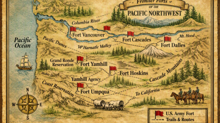
This map illustrates one of the routes used by settlers and pioneers in the 19th century to move west. This route, the Pacific Northwest Line[1], was protected by soldiers stationed at: Forts Vancouver; Dalles; Yamhill; Hoskins; and Cascades. However, The Far Country was never just a place on the map; it was a pressure, a pull, a long continental breath that carried families, soldiers, and children into landscapes where play and peril lived side by side.
Children were not at every single station on all the Lines and routes, but they were represented and they did play a role in the western expansion. They played in the shade of blockhouses and agency stations, and on the grounds of the former Hudson’s Bay Company at Fort Vancouver. Marbles rolled across hard-packed earth as if testing the edges of a world still being made.
What pushed the pioneer families westward was not destiny[2] but a quieter imperative—an accumulation of routes, forts, ambitions, and imagined futures that shaped childhood in places no child was ever meant to be.
Fort Kearny—Just One Place Where Children & Toys Weren’t
We don’t want to give the impression that children and families were at each Fort, Agency, and Station along all of the routes west. They weren’t. Back East and down South families learned about the routes, trails, and lines west through letters, guidebooks, emigrant manuals, newspapers, word‑of‑mouth networks, military reports, and Hudson Bay Company and missionary correspondence[3]. And yes — some locations were absolutely not advertised, either because they were militarily sensitive, commercially competitive, or simply too dangerous for public promotion.
We use Kearny as one such example, but it is far from a singular outpost where families never ventured. Fort Kearny sat on the Platte River Road, the main trunk of the Oregon Trail, California Trail, and Mormon Trail. It was the great convergence point where all three routes braided together before diverging again farther west.
Fort Kearny (1848–1871) was named for General Stephen Watts Kearny, whose surname has no second “e.” When the nearby settlement grew into a town, railroad paperwork and postal records began spelling it Kearney—likely due to clerical error or phonetic spelling. The “mistake” stuck, and the town and county kept the extra vowel.
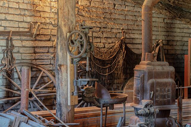
.Highsmith, Carol M, photographer. 0-05. Photograph. Retrieved from the Library of Congress, 10-05
<www.loc.gov/item/2021758092/>.
Why No Marbles At Fort Kearny?
Fort Kearny differs from forts like Fort Vancouver or Fort Stanwix, where children’s domestic life is archaeologically visible. Kearny’s primary function (1848–1871) was trail and telegraph protection and logistical support, with few family quarters and a more transient population. A portion of the blacksmith shop at Fort Kearny State Historical Park recalls an important outpost along the old Oregon Trail near present-day Kearney, a city in south-central Nebraska.
The telegraph lines along the various routes west were built and maintained by the Army Signal Corp, which had been reconstituted after the Civil War. The first transcontinental telegraph line (completed 1861) ran from St. Joseph, Missouri, to Sacramento, California, linking the eastern United States to the Pacific Coast. This line was private and it was built and maintained by Western Union.
Western Union established its first western offices in the early 1860s, and by the time the company consolidated its lines under the Pacific Telegraph system, the frontier had a new kind of heartbeat.
Each morning, clerks unlocked the office, checked the batteries, and tested the wire before the day’s traffic began. The telegraph key tapped out orders for freight, notices from territorial courts, and news from distant rail hubs—turning raw, unsettled country into a place where business could move faster than any rider on the trail.
What Has Been Found At Fort Kearny?
The major excavation campaign (1960–61), which is summarized in Nebraska History (Grange 1963)[4], provides the clearest artifact inventory. It includes: tools and utensils such as blacksmith and carpenter shop debris.
Blacksmith shops were a central hub in stations like Kearny. Shoes were reset on exhausted mules and horses. Wagon rims were shrunk and hammered into place, and broken trail gear was coaxed back into service under a shower of sparks.
In a fort without families, the forge became the closest thing to a communal center: soldiers, teamsters, scouts, and migrants all passed through its open doorway, carrying the problems of the trail and leaving with tools restored, axles tightened, and wheels trued for another hard push west.
The archaeological record reflects this adult world of repair and urgency—blacksmith debris, iron scraps, slag, and hardware—rather than the domestic scatter of toys or ceramics.
Other artifacts found at Kearny and other Stations include smoking pipes made of both clay and stone; personal objects like buttons, buckles, and small domestic items. Weapons and ammunition is found along with glass refuse like bottles; and finally, small miscellaneous objects.
None of these categories include marbles, and the artifact photograph in the George article likewise shows no toys or game pieces. Could marbles have been found at Fort Kearny and be held in private collections? Possibly, but there are no marbles nor toys referenced in the 1960–61 excavation report: Fort Kearny archival collections; NRHP documentation; OCTA trail‑related imagery[5].
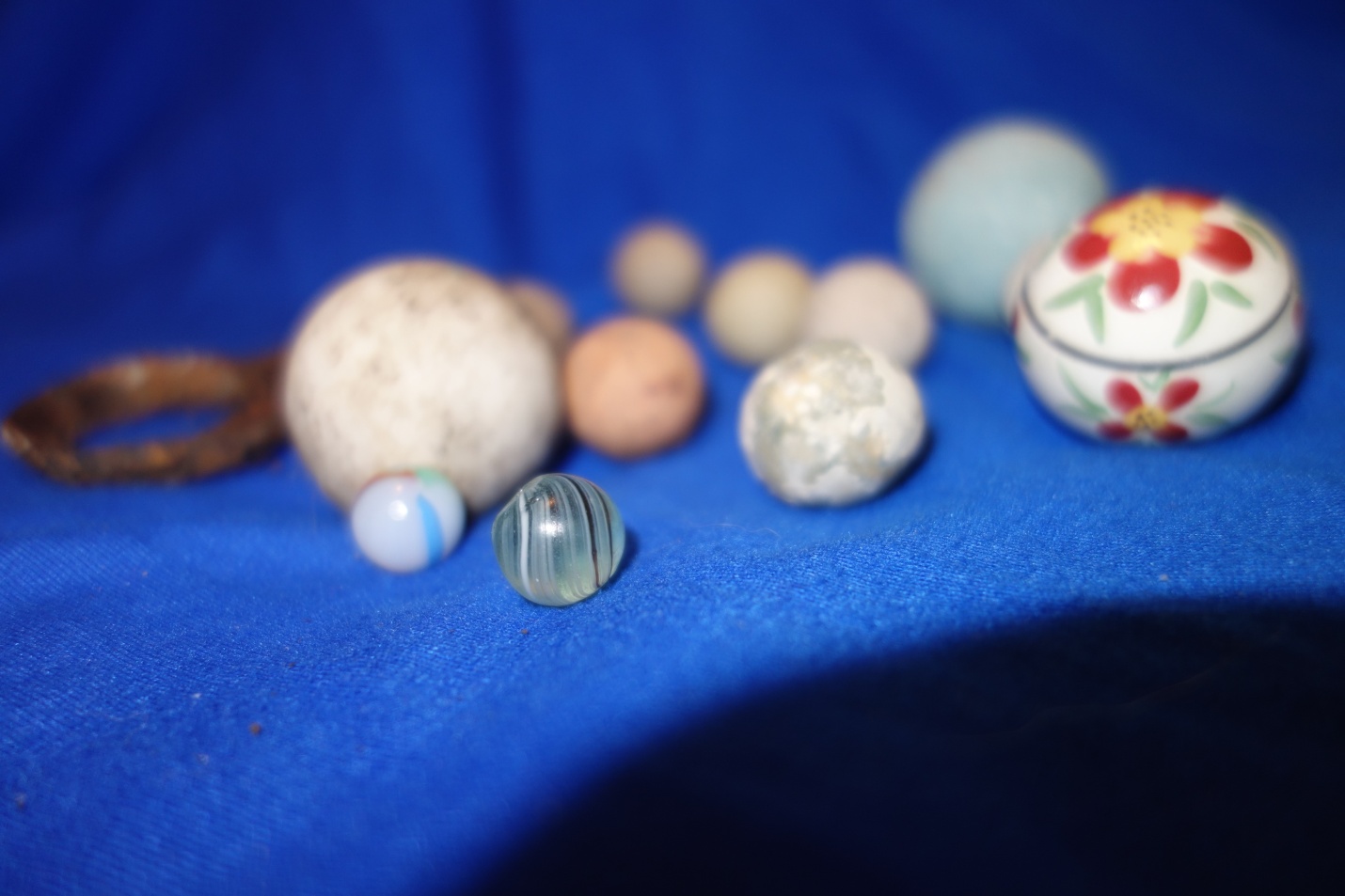
Photograph by Jo Garrett
From Clinkers & Hammer Scale To Marbles & Toys
At Fort Kearny, on the Platte River/Oregon Trail Line, archaeologists have found blacksmith slag, smoking pipes, and bullets and weapons. No marbles, slate pencils, doll fragments. Game pieces are all absent.
So, let’s turn our attention further north to the Pacific Northwest Line. Here, by contrast to Kearny, Fort Vancouver operated as a full community. Families lived on site, children attended school, and domestic life unfolded alongside military and commercial activity.
Excavations routinely recover marbles—clay, stone, and early glass—along with other small items that drift from pockets, scatter during play, or are simply lost in the bustle of everyday life. These artifacts do more than mark presence; they reveal rhythm. Where marbles appear, you find yards, porches, footpaths, and informal play spaces. Where they do not, you find posts like Kearny: adult, utilitarian, and oriented toward the demands of the trail.
Looking Back, Looking Forward
In addition to Fort Vancouver, the Pacific Line includes Forts Dalles, Yamhill, and Hoskins. We wrote a story, “Small Footprints in Hard Places” (https://Thesecretlifeofmarbles.com) which includes what we know about family life at Forts Yamhill and Hoskins where marbles and other toys are found.
That leaves The Dalles in addition to Vancouver. Like at Kearny, archaeology at Fort Dalles shows a post geared toward throughput—soldiers, freight, Columbia river traffic, and repair work—rather than family life. Excavations have produced hardware, military fittings, and blacksmith debris, but no documented marble finds. Its material record matches other adult‑only transit forts: functional, work‑driven, and missing the small, durable play objects that mark posts like Vancouver.
Vancouver—A Family Home On The Broad Columbia
Fort Vancouver absolutely became the end of the trail for many settlers. This was indeed The Far Country. They had pushed off from Saint Louis or Independence some four to six months earlier. For everyone the pull north and west had been a great adventure.
Many pioneers chose to settle at the Fort or in its immediate vicinity like Oregon City, the Willamette Valley, and later Vancouver City itself. It was one of the first places where the westward cry of “Wagons Ho!” finally quieted into community life.
Fort Vancouver began as the headquarters of the Hudson’s Bay Company’s (HBC) Columbia Department, but it quickly grew into a full community. Vancouver developed into a settlement where families lived, children played, and domestic life shaped the archaeological record.
Founded in 1824–1825 on the north bank of the Columbia River, the Fort became the administrative, commercial, and logistical center of Britain’s Pacific Northwest operations. It’s reach extended from the interior posts of the Plateau to the coastal trade networks of the lower Columbia.
Stability at Last
The HBC encouraged stable labor communities, and by the 1830s–1840s, the fort supported housing, gardens, schools, workshops, and family quarters. Children were part of daily life: attending classes, running errands, and playing in the yards and work zones around the fort.
Archaeology reflects this domestic world which continued with the settlers.. Excavations at the Caulkers’ Houses and other residential areas have produced porcelain marbles, slate pencils, toy fragments, and small personal items.
These finds contrast sharply with the slag‑heavy, hardware‑driven artifact fields of Fort Kearny and Fort Dalles, where “Wagons Ho!” defined the rhythm of life and no child’s signature appears.
At Vancouver, marbles are not incidental—they are evidence of community, of stability, and of the everyday domestic life that took root along the Columbia. They anchor the inevitable turn from movement west to settlement, from adult labor to childhood presence, and from the urgency of the trail to the quieter rhythms of a lived‑in frontier[6].
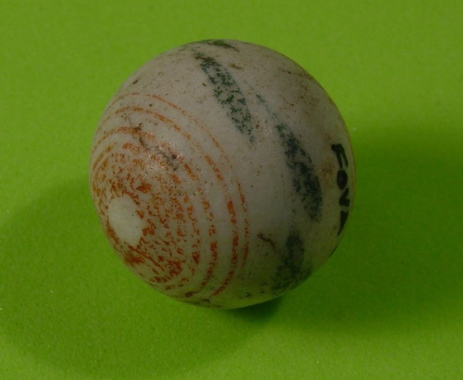
Porcelain marble with hand painted red stripes and green leaves, from the fort’s employee Village.
Fort Vancouver NHS, National Park Service
“Marbles At Fort Vancouver[7]” : China & Variegated Jasper
We were more than pleased when our research led us to Langford’s story about archaeological finds at Fort Vancouver! However, we were at first concerned that the marbles may date to the Hudson Bay Company period rather than families and children at the Fort itself. After all the HBC did lay the groundwork, patterns, and encouragement of family life at the station.
We were relieved to learn that
.The Hudson’s Bay Company’s Fort Vancouver began to decline in prominence in the late 1840s and early 1850s. A contributing factor in this decline was Oregon Treaty, which formally placed the British fort in American territory, and the founding of the U.S. Army’s Vancouver Barracks, built adjacent to the fort in 1849. Given the date of these “chinas” (post 1846), and the various archaeological contexts from which they were recovered, we assume most of the marbles were the playthings of army officers’ children. The majority of the marbles were found in the Village …west of the fort, which was later the site of the Army’s Quartermaster’s Depot and other military structures. [Emphasis added].
Baumann calls this first China [photo above] a “Coil and Leaves” and there is a photograph of it on page #33[8]
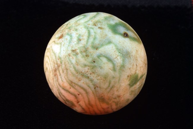
Swirled beige and green marble, found by archaeologists from the Bachelors’ Quarters’ privy inside the Fort Vancouver stockade.
NPS Photo Fort Vancouver NHS, National Park Service
This is a gorgeous marble which collectors often call a variegated Jasper. This term can be misleading, however, because this is a clay marble and it is not made of stone.“Diagnostic Artifacts[9]” tells us that these variegated clays range from the American Colonial Period to about World War I and that they are the result of incompletely mixing different color of clays which create the variegated appearance of agateware marbles.
We are unsure of how many colors of different clays are used in addition to the white base, but we believe we have seen blue, black, and, possibly, red. But remember, the colors are of clay and these marbles are not painted.
These marbles seem to be scarce: we have only found one, in North Georgia, in some 25 years of looking.
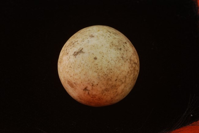
Porcelain marble, circa 1830-1860, excavated from the Village area.
NPS Photo Fort Vancouver NHS, National Park Service
Clay And Glass
A porcelain marble [photo above] is a man-made ceramic sphere which is produced from refined clay, feldspar, and silica, fired at extremely high temperatures of around 1.200 – 1,400 C. This high firing vitrifies the clay body, making it hard, dense, and nearly non-porous.
These marbles are harder than low-fired clay marble. They have a smooth glass feel, and they resist moisture and staining. They were common throughout the 19th century.
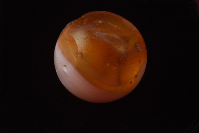
Glass marble found by archaeologists in the Village area. NPS Photo Fort Vancouver NHS, National Park Service
We have nothing to add about this particular glass marble. However, we know that glass marbles from Germany became more common in America after ca. 1850.
Langford concludes her story with these ideas:
Young players must have held on to their prizes pretty tightly; after over 120 years of use (plus over 60 years as a national park) only 40 or so marbles have been found. Though a tiny part of the archaeological collection, they speak to an often forgotten aspect of the site: children, their possessions, and pastimes.
The Smallest Travelers
History remembers the wagons, the oxen, the rivers crossed, and the mountains climbed. It remembers the pull of the far country as movement across maps. But those wagons carried families, and families carried children.
Youngsters walked, worked, played, and endured the long overland journey beside their parents. Depending on the Trail chosen, children walked and rode some 2,000 miles. Sources on the emigrant trails specifically describe children playing games while walking and during camp stops, reminding us that childhood did not disappear simply because the road west was long and hard[10].
Somewhere among the necessities packed for a new life were the small possessions of childhood. A marble required almost nothing: little room, no batteries, no instructions, not even another child and a patch of earth. Children could play marbles alone inside the wagon.
Marbles was a game often played alone both by adults as well as children. Ceramic marbles were inexpensive and enormously common among nineteenth-century children’s toys, and today they survive in archaeological contexts. A marble recovered at a western Fort, Agency, or settlement therefore tells a story larger than itself[11].
The adults carried a dream westward. The children carried childhood with them. And sometimes, both along the way and at the end of two thousand miles or more, they left a little piece themselves behind.
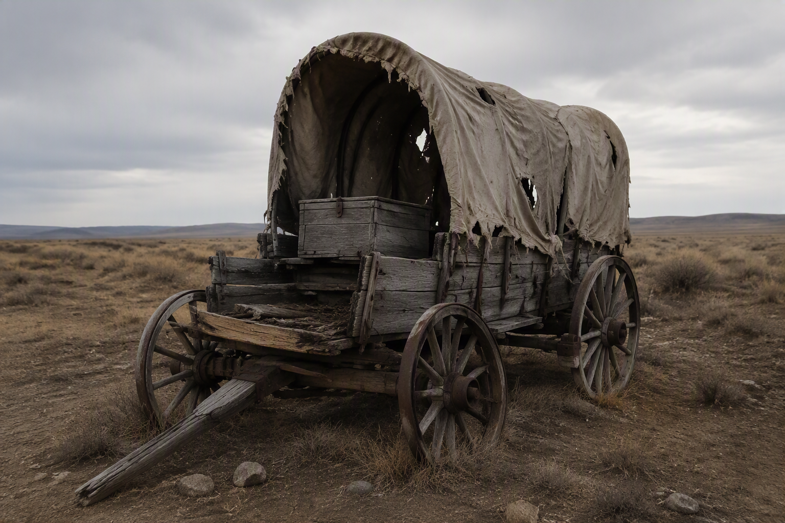
The End of the Trail
Made by Microsoft AI
References
- The Frontier Fort Network (1800–1890) The U.S. Army built a chain of forts across the West to support: migration; First Peoples policy enforcement; treaty oversight; road and telegraph protection; supply distribution; territorial administration. Other routes & Forts include The Platte River / Oregon—Trail Line —-Fort Kearny (Nebraska), Fort Laramie (Wyoming), Fort Fetterman, Fort Bridger (Wyoming). The Santa Fe Trail Line—Fort Leavenworth, Fort Riley, Fort Larned, Fort Dodge, & Fort Union (NM). The Texas Frontier Line (A defensive arc against Comanche and Kiowa raiding zones) —Fort Belknap, Fort Phantom Hill, Fort Griffin, Fort Richardson, & Fort Davis & The Southwest Line (Arizona & New Mexico)—Fort Bowie; Fort Huachuca; Fort Apache; & Fort Stanton. ↑
- John L. O’Sullivan, editor of the United States Magazine and Democratic Review, first used the phrase “manifest destiny” in 1845 to describe what he saw as the nation’s natural westward momentum. The term’s ideological weight, as opposed to its physical expressions, is acknowledged here only to situate the period’s language; this story relies on quieter frames of continental pressure and cultural drift rather than O’Sullivan’s expansionist rhetoric. You might want to see the print and text @ “Manifest Destiny Key Facts” (The Editors of Encyclopaedia Britannica @ Manifest Destiny | Key Facts | Britannica 9/22/2026). American Progress is “a color print from about 1873, an allegorical female figure of America leads pioneers and railroads westward, in accordance with the concept of Manifest Destiny. The print was made after an 1872 painting by John Gast.” ↑
- You are encouraged to check “Hudson’s Bay Company Collection, 1690 – 1970” @ Hudson’s Bay Company collection – Archives West ( 9/22/2026) & “Writing the Journey into the Nineteenth Century American West” By: Brian Wright *23, Kate Carpenter *24, and Poorvi Bellur *25 @ Writing the Journey into the Nineteenth Century American West | Digital PUL (9/22/2026) & For the role of Fort Kearny and Fort Vancouver as transit and supply posts rather than advertised destinations, see Encyclopaedia Britannica, “Oregon Trail.” There are also dozens of books on the topic of the western forts and routes west. For example: Marcy, Randolph B. The Prairie Traveler: A Handbook for Overland Expeditions. Washington, D.C.: War Department, 1859. The most widely used U.S. Army guidebook; covers routes, water sources, distances, and survival techniques. Hussey, John A. Historic Forts of the Old West. Palo Alto: American West Publishing Co., 1963. Contains primary excerpts on emigrant interactions with forts and the information networks surrounding them.
- ↑Olson, James C, James L. (James Lee) Sellers, Addison Erwin Sheldon, and Nebraska State Historical Society. Nebraska History. [Lincoln: Nebraska State Historical Society] @
- The National Register of Historic Places (NRHP) is the United States federal government’s official list of sites, buildings, structures, districts, and objects deemed worthy of preservation for their historical or artistic value, established under the National Historic Preservation Act of 1966 (NHPA) and administered by the National Park Service (NPS). For OCTA see https://octa-trails.org/archaeology-keyword/geographic-visualization/ 9/23/2026↑
- We recommend that you check the National Park Service (NPS) website “Fort Vancouver” @ Fort Vancouver National Historic Site (U.S. National Park Service) (9/23/2026) John A. Hussey. The History of Fort Vancouver and Its Physical Structure. National Park Service, 1957 @ “Historical Studies” NPS @ Historical Studies – Fort Vancouver National Historic Site (U.S. National Park Service) (9/23/2026); Part I, “Our Manifest Destiny Bids Fair for Fulfillment”: An Historical Overview of Vancouver Barracks, 1846-1898, with suggestions for further research, Pdf; Part II, The Waking of a Military Town: Vancouver, Washington and the Vancouver National Historic Reserve, 1898-1920, with suggestions for further research, Pdf; “Overview of Archaeological Exploration 1957 – 1958” @ Overview of Archaeological Exploration 1957-1958 – Lewis and Clark National Historical Park (U.S. National Park Service) (9/23/2026). and especially National Park Service, Fort Vancouver National Historic Site. Small Finds, Big Stories: Children’s Toys—Porcelain Marbles from the Caulkers’ Houses (c. 2018) & “Marbles at Fort Vancouver” @ Archaeology – Fort Vancouver National Historic Site (U.S. National Park Service) 9/23/2026 ↑
- Theresa Langford, Curator. “Marbles at Fort Vancouver.” National Park Service @ Marbles at Fort Vancouver (U.S. National Park Service) 9/24/2026 ↑
- Paul Baumann, Collecting Antique Marbles Identification and Price Guide, 4th Edition.Iola, WI: Krause Publications, 2004 in his Chapter “China Marbles”. You might also want to see Everett Grist, Antique & Collectible Marbles, Third Edition. Paducah, KY: Collector Books, 1992. Starting on page #37. ↑
- ” An online guide to artifacts from the Middle Atlantic by the Maryland Archaeological Conservation Laboratory” @ Diagnostic Artifacts 2/24/2026
- See “Pioneer Children’s Games and Toys” 2 California Trail Interpretive Center @ Pioneer Children’s Games & Toys | California Trail Interpretive Center 9/24/2026 ↑
- Jeff Carskadden and Richard Gartley. “A Preliminary Seriation of 19th-Century Decorated Porcelain Marbles.” Historical Archaeology, 24.2 (1990, 55-69. ↑